To hear the media tell it, Iraq is disintegrating. Violence is widespread and progress made since the fall of Saddam has stagnated or even reversed. Others, like Iraqi bloggers or returning US military tell a different story. I decided to try to map the violence in the country to try to get an visual idea how widespread the violence was. I wanted to see how much of the country of Iraq was shooting at the Coalition.
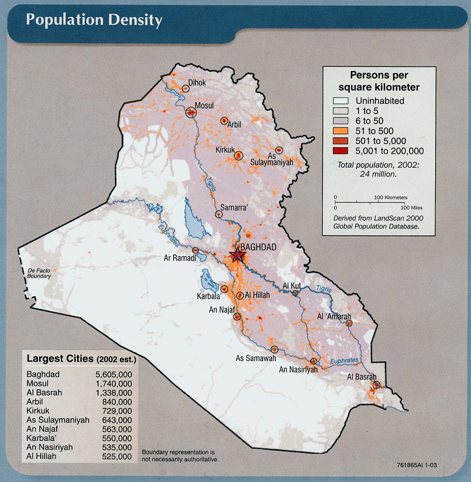
First here is a map of Iraqi population distribution. Notice that most of Iraq’s population lives east and north of the Euphrates river which nearly bisects the country. The greyish areas in the east between the Tigres and the Iranian border are analgous to the American mid-west, with lot of contiguous habitation, small farms and towns and no major dead zones. The areas east of the Tigres turn rapidally to desert. Population hugs the rivers. Most of the area south and west of the Euphrates is functionally uninhabited. The Al-Anbar province in particular is nearly completely deserted except for the river valley.
I mapped all 58 U.S. combat fatalities for the month of September to date using data made available at GlobalSecurity.org. The map color codes the number of U.S. fatalities resulting from enemy action in each of Iraq’s 18 provinces. Only four of the provinces had any U.S. fatalities. 14 of the provinces had zero fatalities. (The British down in Basra had zero fatalities from combat in September).
Here’s the map.

See all the green?
Heres the breakdown fatalities by province:
Baghdad; 21
Salah ad Din: 2
Diyala: zero
Wasit: zero
Maysan: zero
Al Basrah: zero
Dhi Qar: zero
Al Muthanna: zero
Al Qadisyah: zero
Babil: zero
Al Karbala: zero
An Najaf: zero
Al Anbar: 30
Ninawa: 2
Dahuk: zero
Arbil: zero
At Ta’mim: zero
As Sulaymaniyah: zero
Area unknown: 3
See all the zeros?
Of course, other months would have slightly different maps. During Al-Sadar’s uprising the province of Al Najaf would have been red for example. But the overall pattern is clear. The “insurgency” is geographically concentrated. Most of Iraq sees little or no violence directed against the Coalition. For example, a minimum of 29 of the fatalities occured within a 50 kilometer radius of a point halfway between Falujah and Baghdad.

The violence shown on TV seems intense but remember that it would take only a few hundred individuals to carry out these attacks. 9/11 was carried out by 19 individuals with a supporting group of another 40 or so. It takes a team of only 2 or 3 individuals to assemble, deploy and detonate a roadside bomb of the kind that has killed the majority of U.S. personnel. Terrorism does not have to involve a large section of the population in order to create a mediaphillic event.
We are looking at a small scale, localized “insurgency” with a very limited operational range. There is no evidence the “insurgency” has wide support within the population either numerically or geographically. Given time, they can be squeezed and destroyed.
(cross posted at Shannon Love’s Blog)
(Update 30 Sept: Somethings brought out in the comments. (1) The map was accurate as of 25 Sept 2004. Deaths have occurred since then in other areas. The British had suffered no causalities in the month of Sept until the 27th for example. (2) I mapped combat fatalities only because they are the best indicators for the intensity of the fighting. Injuries are inconsistently reported and non-combat deaths don’t tell up much about the intensity or distribution of the insurgents and terrorist. (3) September has been a relatively quite month overall. My main point in creating the map was to make that graphically clear. The media was in my opinion letting its if-it-bleeds-leads mentality convey a distorted picture of the conflict during the month of Sept.)
Thanks. This gives us a useful perspective.
I was going to say, what is wrong with this country (USA) and why do we allow our populace to be subverted by socialists. What I really mean is that the MSM is taking it hard in the neither region and this is thier last feint at a “battle” for thier worth. Their “enemy” bush is going to be elected by a land slide, and they can basically blame themselves for pressing the republicans into a corner over “social” issues, which they have in turn absorbed into thier own platform and legislation. Democrats: Obsolete. If the so-called bush opposition wanted to win, they should have feilded a canidate with the same strategy: An ultra “conservative” who was more hawkish than bush, more libertarian on social and economic issues, and im sure it wouldn’t be hard to feild a better public speaker. Toastmasters anyone???
Adapt and overcome opposition party…Please.
sorry for the spelling. I just moved down to college; everclear and PBR is about all I can afford currently…
Shannon,
the combat deaths occured in areas bordering on Syria and Saudi Arabia (I think we can ignore Turkey), while there were none in the Shiite controlled areas adjacent to Iran (although there is fighting in Sadr City, a Shiite quarter of Baghdad).
Doesn’t that suggest that Syria and Saudi Arabia are behind the direct attacks on the coalition troops, while Iran is more interested in gaining influence in the mainly Shiite provinces in tzhe East?
That doesn’t necessarily mean that Syria is in direct collusion with Al Queda, for Syria also is one the countries (along with Egypt and Jordan), where America is sending suspected terrorists for interrogation
Ralf Goergens,
“Doesn’t that suggest that Syria and Saudi Arabia are behind the direct attacks on the coalition troop…”
Not really. The major correlation is with ethnicity. The areas currently effected are heavily Sunni. These Sunni have dominated Iraq for centuries and they resist losing their domination.
The attacks are so small scale that they do not require any external support. Baathist deadenders have access to literally truck-fulls of cash that Saddam squirreled away before the invasion. They are paying $2,000 to $3000 (equivalent in purchasing power to $20,000 to $30,000 in the U.S.) per roadside bomb.
Out of curiosity, what does the map look like if you were to plot Iraqi (civilian) deaths only? Are they also heavily concentrated in the same areas?
“Out of curiosity, what does the map look like if you were to plot Iraqi (civilian) deaths only?”
I don’t have any hard data but based just the anecdotal reports in the media I would say yes. Since most of the civilian deaths are the result of terrorist bombings, most of the deaths will be in the Baghdad area. Likewise, civilian deaths due to military operations will shadow U.S. military fatalities and be concentrated in the same locations.
There are other causes of civilian deaths as well. There is a problem with crime, score settling and traditional feuds. Those will be more symmetrically distributed. Whether those get counted as being related to the liberation is a matter of arbitrary definition.
The new Iraqi government could learn a lot from Israel in dealing with an unscrupulous, bloodthirsty insurgency made up of madmen and suicidal maniacs.
I see the civil war scenario. I am not sure if there are two or three separate states possible. The Baathists might be trying to take land for Syria and/or there is a possibility of a jihadist state.
There has been sabotage in the south (oil lines) but that is not as important as human life.
Rarely have I witnessed such blatant misrepresentation of data but well done anyway. For what its worth wouldn’t you think that US casualites may have something to do with the zones that the US are responsible for? Are fatalities the only casualties the US suffers? Did you plot the injured and wounded?
Also you’re facts are just plain wrong regarding the rest of the country. British newspapers report that the fighting in the south has been the most intense since the invasion with the British base at Amara hit by over 400 mortar rounds and just yesterday two British soldiers were killed in Basra… yet you have the southern provinces down as nice and safe. I trust you’ll be going there on your holidays will you?
A couple of other matters, according to the Iraqi Health ministry Coalition forces and Iraqi security forces are killing twice as many civilians as the insurgents. So who are the murdering barbarians exactly? And as for Israel being a role model, please! If you want a West Bank on Steriods to exist in Iraq then go right ahead and hold up those who have shot 4 dead school children at their desks in the past 18 months. http://news.bbc.co.uk/1/hi/world/middle_east/3693860.stm
All in all a pretty lame attempt at convincing yourself that white is black, but still when your philosophy is contradicted by reality then its any port in a storm.
Have fun with your maps.
Speaking of lame, a quick check of your BBC article reveals that the 4 Palestinians in question were hit by “stray bullets” that Gaza-based UN personnel claim came from Israeli troops. So the people blaiming Israel, without evidence, for the shootings are people who live in a region controlled by Israel’s enemies, who have a history of intimidating UN personnel and journalists. The people quoted in the article would be risking their lives if they blamed anyone other than Israel for whatever misfortunes occur. Not to mention the obvious fact that there would be no shooting at all if terrorists weren’t using Gaza as a base for mortar and rocket attacks on Israeli towns.
Well, did some quick numbers but don’t have all the geographical data, civilain deaths based on iraqbodycount.org:
Baghdad – 78
Baquoba – 1
Fallujah – 91
Samarra – 1
Ramadi – 3
Kirkuk – 20 (three outside of city)
Mosul -16
Hillah – 3
Doesn’t seem all that widespread from those either.
Woeful try there Bishop, so the Jewish army refuses to acknowledge it shot kids so its Not Proven..you’d never make a judge. They murdered them and if you want to email me privately I can furnish you with numerous other examples of murder by the Jewish terror regime. You don’t want to hear this of course because it intrudes on the disinformation cocoon you’ve wrapped yourself in. BTW go find out what bunch of thugs are responsible for the greatest carnage at a UN facility and I’ll give you a clue; its not the arabs… so much for intimidation.
Now as we all know Iraq is so safe that US journalists can’t travel out of their Baghdad bunkers so why don’t you go and find out for yourself? No seriously, if Iraq is so safe then jet across and report back on the great deception that is being perpetrated. You might have some difficulty of course because large areas of the country are outwith the control of the US and their puppet regime but hey, if you can’t report then it doesn’t happen.
Iraq is safe, all is well, ignore the mounting deaths, its not our fault, we must murder the people in order to save them.
As for that map, I’ve mailed it around and the laughter truly is tremendous. Thank you for a glimpse into gimp politics.
PS I won’t be troubling you anymore as you obviously aren’t up to it. Bye bye.
Ah, the “Jewish terror regime” — glad that’s out in the open. I take it you don’t like Jews.
You also ignore the questions I raised about your accusation of murder against Israeli troops. Your only response is to repeat the accusation. As I said before, lame. You can’t even tell the difference between me and another commenter. Maybe you should cut back on the nerve medicine.
Your threat to leave our blog is comical, but it’s also typical behavior for trolls who try to bully their way through arguments but meet principled opposition. You simply do not have the ability to hold your own in a serious discussion, do you?
Your map is garbage. I doesn’t account for the 3 Polish soldiers killed near Al Hillah, the 4 British soldiers killed near Basra or the American soldier killed near Tikrit.
http://icasualties.org/oif/Details.aspx
If you’re pinning an argument on that BBC piece, you’ll need something more substantial than that. “The United Nations….investigators believe that Raghda was hit by a bullet fired by Israeli soldiers.”” The UN says..””The UN believes that”Please, you’ve got a dead gunshot victim, you’ve got the bullet(s) that killed her. It doesn’t take much to determine the ammo type and likely weapon. There should be no need for the UN to “believe” anything. The proof is all around them, just follow it up. Jonathan would never make a judge? Neither would you.
There is no use in making a statistical point out of only 25 days of combat. The insurgency varies in strength in different parts of the country. A suggestion: Make another map for the three last months, and this time also include losses for Iraqi security forces AND non-US coalition troops.
The last map is misrepresentative, there are several cities (Ramadi, Samarra, Baquba, Tall Afar) where there’s a periodically strong insurgency capacity.
Coca Cola Jr,
My point in making the map was to address the specifics of media reporting in the middle of September. I felt they bordered on the hysterical when Sept was not a particularly bloody month in Iraq. The map only tracks US and British deaths from 01 Sept to 25 Sept for that reason.
However, I can safely say that a map of all Coalition casualties in Iraq would look substantially like the one a created for September. Most causalities would be clustered in Al-Anbar and Baghdad with only a sprinkling in other areas.
The geographical distribution tells us a lot about the insurgency. It is for the most part comprised of Sunni’s who themselves represent less than %20 of the Iraqi population They are using weapons, training and money that Saddam put in place to fight the Mogadishu-like urban guerrilla war.
No more than a small fraction of the Iraqi people are actively supporting the insurrection. I would say less than %15. Those that do oppose are geographically concentrated. If this were not true the fighting would be far more widespread and far more bloody.