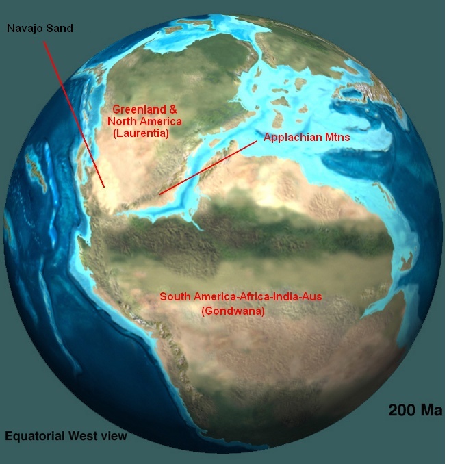
200 million years ago North America sat about 20 degrees above the equator. The newly born Mid-Atlantic Ridge was breaking Pangea apart, separating Laurentia from Gondwana, and one arm of the rift feature was beginning to propagate through Gondwana, beginning the separation of South America as well.
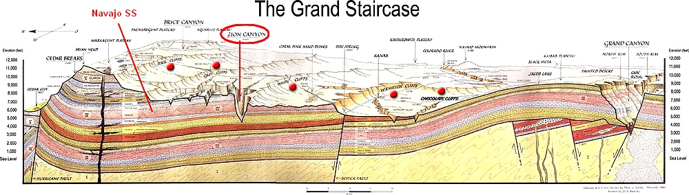
Western Laurentia was a sea of sand, the remnants of which are still found all across the western USA as massive cliffs of buff colored sandstone, often over 1,000 feet high. The defining features of the Navajo Sandstone, besides its color, are the the large-scale cross-bedding and its tendency to weather across its exposed top surface into domes and rounded forms. The Navajo was one the largest seas of sand dunes ever seen on the planet. The most spectacular exposures of the Navajo are to be seen at Zion National Park where it reaches more than 2,500 feet in thickness. When the Colorado Plateau was uplifted in the Laramide Orogeny in last 45 million years, that created a lot of elevation difference between the uplifted ground surface and sea level, which allowed water to cut deeply through the rock, exposing it to erosion. If you look at the cross section of the Grand Staircase below, you’ll see that more than a mile of rock has already been eroded from the ground above the Grand Canyon, the Vermillion Cliffs, and the White Cliffs of Navajo.
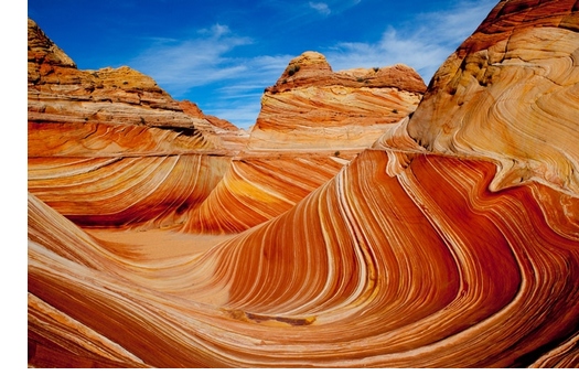
Cross bedding is a visible remnant of the dunes from which the sandstone formed. Dunes form when sand finds itself under a current of air or water, and the form and scale of the dune features are diagnostic of which environment created them. Those formed by winds are called aeolian (Aeolus – Greek God of the Winds) and those formed under water are simply called marine. Where did all the sand come from? It must have been an almost endless source providing sand over a very long period of time.
Provenance of the Navajo sands:
Rahl et al. (2003) collected zircon grains from the Navajo Sandstone, dated them using radiometric techniques, and compared these dates with source regions to infer the origin of the Navajo sands. Radioisotope dating of minerals in sedimentary rocks and the chemical signatures of the minerals can constrain sediment sources (provenance). They conclude that the majority of the Navajo sands were derived from the Appalachian Mountains:
“We envision a system in which rivers with their headwaters in the Appalachians carried material to the Jurassic western shore of North America, flowing to the north of any residual topography associated with the Ancestral Rockies. From there, material was blown southward and incorporated into the Navajo-Aztec-Nugget erg”
Long before they were understood to be the same formation, the discontinuous outcrops and exposures had been given different names, Aztec Sandstone in Arizona/Nevada and the Nugget in Wyoming. One of the more impressive accomplishments of early 21st century geologists has been the organizing and interpreting of data from decades of mapping, field work, and lab work and their creation of paleomaps, and by inference paleoclimates; snapshots through time that have begun creating a geological and climatological evolutionary model of the Earth.
More:
Geologists revisit giant Zion landslide
Bedforms and Cross-Bedding in Animation
Coyote Buttes Erosion Sculpted Navajo Sandstone (GigaPan are super-hi-res photos that are pannable and zoomable)
Beauty in The Wave at Coyote Buttes (NSFW)
Thanks. Michael, do you know of any place comparable to the Colorado Plateau?
I am not. Geologist Wayne Ranney has traveled the world doing research and has written that while some of the features are found elsewhere, nowhere else do you find all of these features in one region. Consider: The Grand Canyon, Bryce Canyon with its limestone hoodoos, the arches and canyons in Canyonlands and Arches National Park, the massive cliffs and canyons of Zion, the Painted Desert, the Petrified Forest, the spectacular eroded monoclines of the San Rafael Swell and the Waterpocket Fold in Capitol Reef, Upheaval Dome, the Rocky Mountains…I don’t think there’s anywhere quite like it. The whole region is a national treasure and draws millions of tourists every year.
“The whole region is a national treasure and draws millions of tourists every year.”
It’s kind of surprising how many of those visitors are foreign. The shuttle bus through Zion Canyon is filled with European and Asian languages chatter. The region truly is famous throughout the world.
I remember sitting in a restaurant about 50 miles from Grand Canyon with one of my daughters. I didn’t exactly speak to everyone of hear everyone speak, but from where we sat and where we walked we were the only ones speaking English. The visitors mostly seemed to be Europeans.
Heh.
Photographing the person who is photographing the people who are taking photos. That’s three-deep photographic recursion.
Photographing the person who is photographing the people who are taking photos. That’s three-deep photographic recursion.
My father’s side of the family had a lot of camera buffs. We have a number of slides from 60-70 years ago of people taking photos of people taking photos.
I spent a few days camping in Capitol Reef national park in an old Mormon orchard. It is truly amazing with giant cliffs overlooking the camp ground and a rushing stream behind me.
Hiking up the narrow fissures in the cliffs was one of the pleasures there.
Not as a crowded as some of the other parks but deeply impressive.
Garden of the Gods in Colorado Springs…