I’m tired of doom and gloom so I thought I would post something a bit different. Sailing !
In 1981, I sailed my 40 foot sailboat to Hawaii in the Transpacific Yacht Race. That year some large yachts had what were called “Sat Nav ” receivers aboard to track a system of satellites that required continuous tracking and took quite a bit of electrical power. It is now called “Transit” or “navSat”
Thousands of warships, freighters and private watercraft used Transit from 1967 until 1991. In the 1970s, the Soviet Union started launching their own satellite navigation system Parus (military) / Tsikada (civilian), that is still in use today besides the next generation GLONASS.[10] Some Soviet warships were equipped with Motorola NavSat receivers.
My small sailboat could not use such a system. It drew about an amp an hour, far too great a drain on my battery. For that reason I used a sextant and sight tables like these, which are published for the latitudes to be sailed.
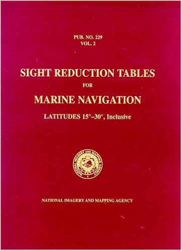
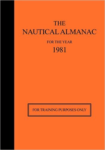
That volume is published for latitudes 15 degrees to 30 degrees, which are the ones we most sailed. Hawaii is at about 20 degrees north and Los Angeles is 35 degrees north. The sight tables provide a set of observations that can be compared with an annual book called a “Nautical Almanac.” As it happens, the Nautical Almanac for 1981 is used for training and is still in print.
The third component, besides the sextant, of course, is a star finder, like like this one, to aid with navigational stars.
The whole system is called Celestial Navigation.
The first thing one needs is an accurate clock. This is the reason why sailing ships need a chronometer in the 18th century.
Harrison solved the precision problems with his much smaller H4 chronometer design in 1761. H4 looked much like a large five-inch (12 cm) diameter pocket watch. In 1761, Harrison submitted H4 for the £20,000 longitude prize. His design used a fast-beating balance wheel controlled by a temperature-compensated spiral spring. These features remained in use until stable electronic oscillators allowed very accurate portable timepieces to be made at affordable cost. In 1767, the Board of Longitude published a description of his work in The Principles of Mr. Harrison’s time-keeper.
The invention is the subject of an excellent books titled, Longitude, by Dava Sobel. In 1981, I used a newly available device called a digital watch, invented by Texas Instruments in 1975. It was very accurate and easy to use. My sextant was made by Weems and Plath, and looks much like this one.
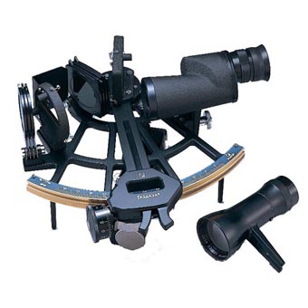
It was, of course, much less expensive 35 years ago. I had a second backup plastic sextant in case the metal one was damaged.
In addition to the sextant, I carried a Loran C receiver which was useful for coastal navigation but not for the ocean beyond about 400 miles. It was useless coming into Hawaii for some reason. Perhaps the transmitters face the wrong direction. I had hoped it would be of some use with the finish area but it was not. I had also used a system called Omega, which was supposed to be useful over longer distances but it was never of any use.
How did we use the sextant ? Mainly it was for latitude. I had previously done a number of Mexican races to Manzanillo and Mazatlan in which latitude by noon sight was useful. The Mexican races were run in the winter when the sun was low. This made noon sights easy as the maximum elevation above the horizon would be no more than 60 degrees. On a small boat, the problem of sun sights is keeping the steady position of the sextant. When the sun is relatively low, this is minimized. On December 21, the sun is at 22 degrees south latitude. IF I am at 30 degrees north latitude, for example, the sun at noon will be about 50 degrees above the horizon.
Unfortunately, Hawaii is at 20 degrees north and much of the crucial days at the final stage of the Transpac Race are run about that latitude and in July when the sun is about 20 degrees north. That means that it is exactly overhead and the ability to take a noon sight is quite difficult. In fact, it is pretty useless.
What is useful in that situation is longitude. This will tell us how far we have come. In addition to celestial navigation, we have what is called a log attached to the knot meter which records our distance sailed. This is quite useful as long as we sail in a straight line. It does not tell us how far we are from our destination. The way to determine longitude in this situation is to use the digital watch as a chronometer and the sextant to measure elevation of the sun above the horizon. The sun rises in the east and passes overhead at noon. The position at 10 AM and 4 PM are very useful in telling us our longitude.
The method of plotting position is using Plotting Sheets once offshore. They have grid lines but there are no landmarks so the latitude and longitude lines are arbitrary. Of course longitude varies as the latitude changes but for our purposes, it does not matter much. The Nautical Almanac is used to calculate the sun’s elevation at the instant of the sight and use this to plot longitude. This was very inaccurate before good chronometers so sailing ships tended to sail “Latitude Lines” or what was called Latitude Sailing, which is probably how Columbus discovered America. He knew the latitude of China and assumed, wrongly, that the earth was much smaller than it is. By sailing north or south to the latitude of the landmark one was seeking, you could sail the latitude line until you hit land. Longitude was less important, unless of course you were wrong about the distance,
In our race to Hawaii , the sky was clouded over almost every night so star sights were very difficult and I never could get three stars in one evening sight. I was able to shoot the North Star near our finish and that helped to bring us in on the right latitude line for Oahu and Diamond Head.
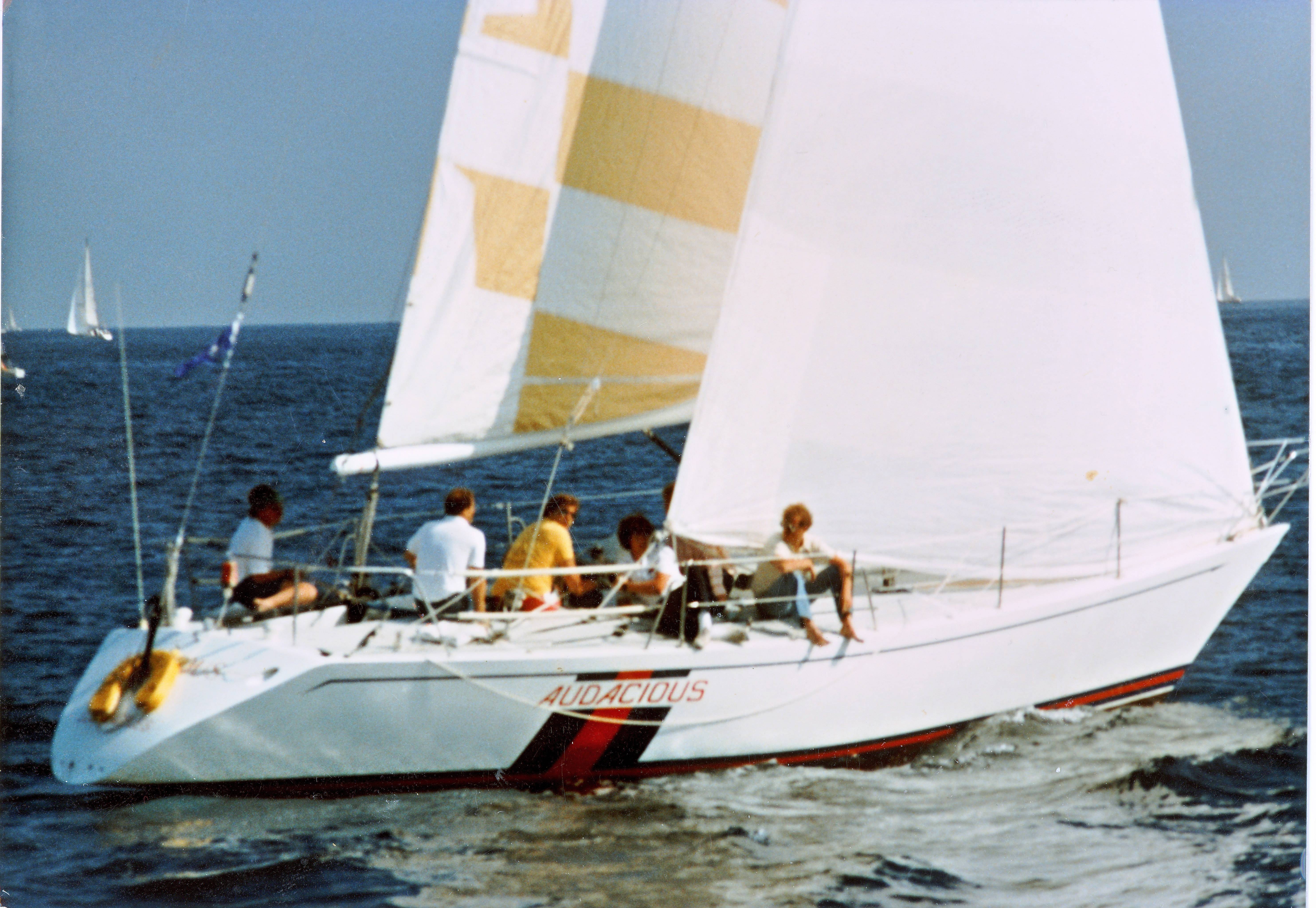
The video shows how we set the 1.5 ounce spinnaker as evening set in and the wind picked up. You can see that, between the time we began to change from the 3/4 ounce and when it was complete, the wind was picking up rapidly. Also the sky is over cast with trade wind clouds gathering. Every day was sunny from about 9 AM to about 6 PM when the clouds would appear. By the time we had a sky dark enough to see a horizon for the sextant, the sky was over cast. The same was true of morning when the clouds would not dissipate until long after sunrise. Finally, I was able to see Polaris thorough a hole in the overcast about a day before the finish and that helped bring us in on the right line. Many boats get south toward Maui and have to jibe and sail north. We came down from north of Oahu, following the wind which backs as we get west of the Pacific High. To avoid running dead downwind, we kept heading north until it was time to jibe for the finish.

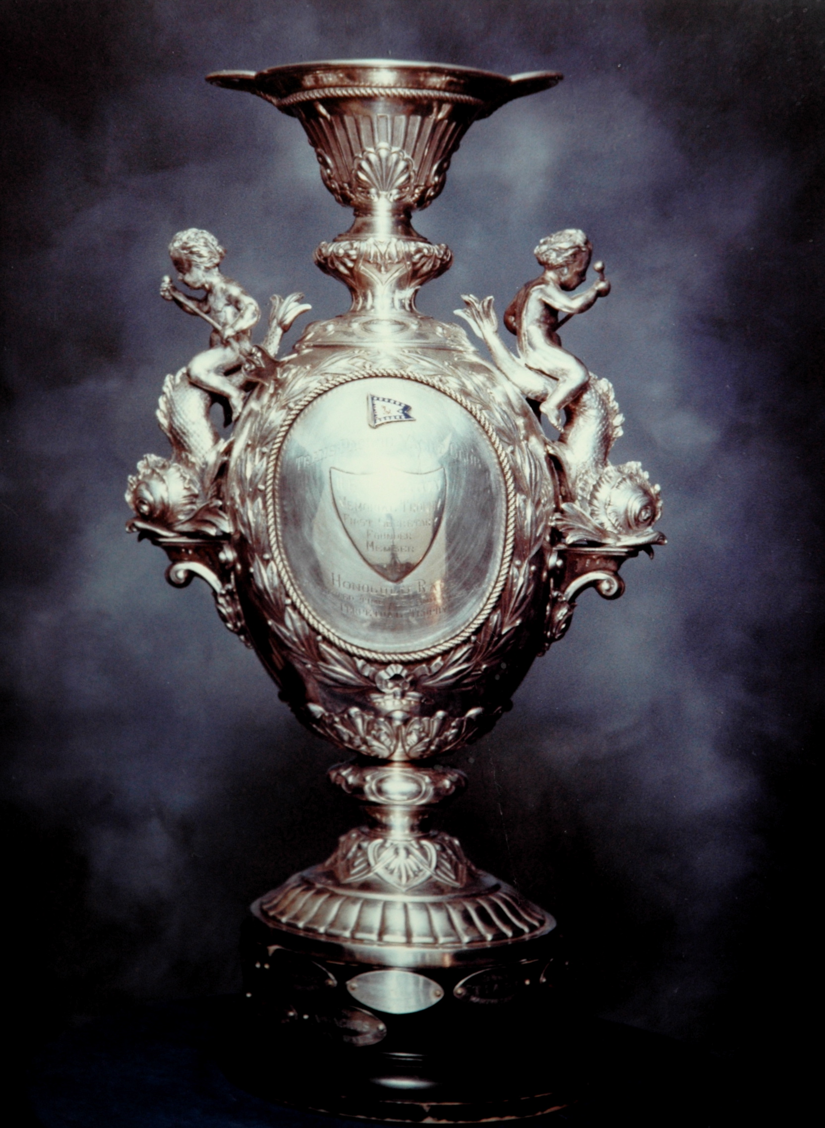
The final word. We missed winning over all by 9 minutes. I can’t find a photo of the overall trophy that was awarded to the first corrected time that year. Our second overall trophy is below.
Gorgeous trophy. I haven’t read Longitude but I have watched it, and even that was excellent if you enjoy history and technology. Because determining longitude was very difficult without a clock, Columbus sailed to the latitude on which he believed Japan lay, then sailed due west. Arriving in the Caribbean, he assumed he’d missed Japan and was therefore in India. He understood the world was round, he just had no concept that an entire other continent lay in the sea between and Europe and Asia.
Very coincidentally, in 1981 I was working for Mieco Corp in Cockeysville Maryland. We had an odd product line that included Loran-C receivers and voice scramblers. I did a lot of the electromechanical design of the C-Master, including designing the enclosure and the printed circuit boards. I was 22 at the time. Here’s an old ad in Motor Boating and Sailing where you can see it: http://tinyurl.com/C-Master-Loran
I had a smaller receiver in my boat that was very useful for races around Southern California and even part way into Mexico. Maybe you know why it was useless going into Hawaii from the east,
Embedded video should be working now.
I have no idea Mike. Loran-C was a coastal region navigation system, as you know. Some areas were prone to atmospheric effects at the 88 KHz band in which it broadcast. The cynic in me wonders if the USN didn’t deliberately interfere with those signals as a way of making it difficult for our enemies to navigate in the region. Maybe that’s a little too paranoid. I believe Loran-C was only recently completely decommissioned.
BTW, very cool to sail all the way to Hawaii. That’s a lot of open, featureless ocean to traverse to find a small island chain. Very good job all around. I’m totally impressed with that.
Thanks, Jonathan. I love to watch these kids do a “peel off” spinnaker change 1500 miles from land just from high spirits. Most if the time we would do such a complicated change in a day race with other competitors in sight.
Most of the kids (all but two were under 22 at the time) are now over 50. Great memories. I was cook and navigator, plus third hand on deck when needed. We had all hands up for major changes like this. We ran a watch system of 8 hour watches by day and four hour by night. That way they “dogged” automatically and everyone got sleep.
I shot a movie of the race , of which this is a clip, and got teased about it but a few years later they all wanted copies.
Relying on satellites for vital military functions such as navigation, and communications, is a potential weakness that our enemies could exploit. We know that China has experimented with anti-satellite missiles.
I was comforted to read the following:
“In the era of GPS, Naval Academy revives celestial navigation” by Tim Prudente on 25 Oct. 2015
http://www.latimes.com/nation/la-na-celestial-navigation-20151025-story.html
“A glimmer of the old lore has returned to the Naval Academy. Officials reinstated brief lessons in celestial navigation this year, nearly two decades after the full class was determined outdated and cut from the curriculum. …
“Maritime nostalgia, however, isn’t behind the return. Rather, it’s the escalating threat of cyberattacks that has led the Navy to dust off its tools to measure the angles of stars. After all, you can’t hack a sextant.
” … the Navy ended all training in celestial navigation in 2006, said Lt. Cmdr. Kate Meadows, a Navy spokeswoman. Then officers’ training returned in 2011 for ship navigators, she said. And officials are now rebuilding the program for enlisted ranks; it’s expected to begin next fall.
* * *
“The perceived need for sextants was taken away,” said Peter Trogdon, president of Weems & Plath in Eastport, Md. The company has sold sextants, and other nautical instruments, since it was founded in 1928 by Naval Academy navigation instructor Capt. Philip Van Horn Weems. …
“According to Trogdon, sales of sextants plunged after GPS. “There’s only a few thousand sold a year,” he said. A lightning strike to a ship’s mast could disable GPS receivers. “Most of those are sold to yachtsmen [who] want to have a backup.”
* * *
“But now celestial navigation is back, and that’s welcome news to maritime enthusiasts. “Fantastic,” said Trogdon of Weems & Plath. …”
Some neighbors sailed to Europe in the 1970s using the old-time navigation tools. Not a bad way to start retirement.
Michael H….I wrote about the LORAN decommissioning here:
https://chicagoboyz.net/archives/11579.html
There are rumors that something called LORAN-E may be deployed for backup navigation and timing purposes, but they don’t sound very far advanced.
“That’s a lot of open, featureless ocean to traverse to find a small island chain.”
After the first four days, we did not see another boat until the finish. We had great conditions and did 2400 miles in 11 days, 20 hours. At night the wind blew hard and squalls sometimes would hit 50 knots for a few minutes. The boat was going 23 knots and the nearly 12 day average speed was over 200 miles per day. One day we did 286 miles, noon to noon.
The boat had been modified by the builder for these conditions and was a wonderful ride going like hell all the time. If the boat speed dropped below 15, the guys below would stick their heads up to see why. The harder the wind blew, the faster we went. Many small boars will dig the bow into the wave ahead but we surfed and at times (I have some video of it) the bow wave would be all the way back to the shrouds. The guys who won overall had an ultralight design and said they could not believe we stayed with them.
I made the movie because surgeons don’t get that kind of time off very often and I thought I would never be able to do another one. We were awfully lucky the Pacific High cooperated.
Awesome post thanks Dr. Kennedy.
@ Mike K – “Boars” was a mistype, but provided a great image for us. Reality as it should have been…
Thanks. It’s always fun reliving good times.
I should have added that I also used, and probably used more PUB 249, Sight Reduction Tables for Air Navigation, which are abbreviated and easier to use. I also had a primitive HP calculator which was programmable with plastic strips containing programs. My wife gave it to me and I used it a bit to do calculations. If we had had more star sights, it would have been more valuable.
I should add that my wife prepared all the meals and froze the entries. She made a set of menus for each day up to 14 days. They were on a ring binder and each days’ food was in a gray plastic bin stored in the stern. We took out the cushions for the rear bunks and had all the bins there. Each bin had the dry and non-perishable things for the day meals. The entries were in the freezer, which was only opened once a day. In the stern we had 12 dozen live eggs she got at an egg dealer fresh and which were never refrigerated. That way they stay alive and if it is not too warm, they will not hatch. The food for such a trip is complicated and she did a great job.
Other boats had straight freeze dried food and one lost their freezer half way and had to throw everything over board. I decided we would eat well even if the weight was a factor. Reconstituting freeze dried food requires water and I was convinced the weight was not that different.
In the morning we would take out the dinner entre’ and put it in an ice chest with the drinks. It cooled the drinks as it defrosted. We had wine for cocktail hour and the crew would put slices of lemon in the wine and called them “Wheels.” We ran out of white wine a couple of days before the finish and had “red wheels.”
An interesting story related to the longitude problem is the contest led Christiaan Huygens to invent the pendulum clock. In the process he inadvertently stumbled on something called the ‘sympathy of clocks’ – inanimate synchrony:
http://www.americanscientist.org/issues/pub/huygenss-clocks-revisited
Strogatz has a good book on the subject call ‘Sync: The Emerging Science of Spontaneous Order’
“That’s a lot of open, featureless ocean to traverse to find a small island chain.”
I recommend this book for its marvellous reconstruction of how the Polynesians did it – again and again.
http://www.amazon.com/The-Prehistoric-Exploration-Colonisation-Pacific/dp/0521476518
A very interesting post, I’m full of admiration for your achievement. As I live near London, I like to visit the Royal Greenwich Observatory periodically. These days, it’s often packed with tourists so an early start will reward. In the museum you will find Harrison’s chronometers. I’ve always been fascinated by the evolution of the designs; versions 1-3 are intricate mechanisms occupying something like the volume of a cube with a side of approximately 18 inches. But version 4 represents a technological leap in both mechanical action and design. It does, as you say resemble a large pocket watch with a diameter of approximately 6-8 inches. Seeing them all together puts the discontinuity into stark perspective. I’ve often wondered about what the ‘Eureka’ moment that must have come to John Harrison with the design of version 4 was like.
There is also the Method of Lunar Distances which allows longitude to be computed *without* an accurate time source…but the computations are much more complex than standard celestial navigation, and the resultant fixes are less accurate:
https://en.wikipedia.org/wiki/Lunar_distance_(navigation)
I’ve been to Greenwich and saw the exhibits. At the time I was there, there were lots of Titanic items. I don’t know if that was a permanent exhibit. I was also very interested in Chichester’s Gypsy Moth as I had read his books.
The digital watch was such a simple item that it just emphasized how much we have changed. Chronometers were a huge problem, which is why the enormous sum was paid to Harrison, although not the 10,000 pounds promised by the Board.
Joshua Slocum used lunar distances for his voyage around the world in 1895 to 1898. As he was returning to New England, the Spanish-American War had broken out. He was sailing up the coast of South America when he encountered a US fleet with the battleship Oregon. They signaled him “Have you seen any Spanish men of war about ?” He answered, “No. Let us keep together for mutual protection.” They declined his offer of protection and steamed on.
How did the Vikings navigate? They had none of the modern instruments but may have used “sunstones” to help?
http://sciencenordic.com/how-vikings-navigated-world
Navigation is an ancient art that far preceded the Vikings. The Minoan Cretans sailed out of sight of land before 1300 BC. The Vikings sailed across fairly short stretches out of sight of land. Of course, we haven’t heard from those who never made it.
The Samoans were great voyagers and used wave motion and stars for navigation. One of my favorite Neville Shute novels is Trustee from the Toolroom which is also one of my favorite sailing novels. He describes the methods used by Polynesians in navigation as part of the novel.
There have been several modern efforts to duplicate the Samoan voyages.
in 1980, Thompson replicated the successful 1976 voyage to Tahiti, becoming the first modern Hawaiian to master the art of Micronesian navigation.
Since that voyage, the Hokuleʻa and her sister canoe the Hawaiʻiloa have undertaken voyages to other islands in Polynesia, including Samoa, Tonga, and New Zealand.
Mike, I was just thinking of the Polynesians. The Polynesians and other Austronesian peoples explored a huge part of the earth’s surface, from Madagascar to Hawaii and Easter Island. They were arguably the greatest explorers before Columbus (their only real competition are their Norse contemporaries in the Atlantic.) Polynesian seafarers probably reached South America at least once, if not making multiple landfalls. In New Zealand, sweet potatoes are called kumara (which is a South American Quechua word, not a Polynesian word), which suggests that Polynesians actually obtained the crop from South American Indians and brought it back to various parts of Polynesia.
The Polynesians were masters of celestial navigation- they used stars to set courses and determine latitude. They had professional navigators who would have memorized dozens of stars, and knew which stars had zeniths at the latitude of different islands. They could also read ocean swells, find low-lying islands from reflections on the bottoms of clouds, and determine distance and direction of land by observing birds.
Have you read “Kon Tiki” ? Worth reading.
Yes, I know about Thor Heyerdahl and his work. I think the settlement of the Pacific was the other way around (Polynesians sailing ultimately from Southeast Asia and eventually reaching the Americas) rather than South American Indians sailing to Polynesia.
The type of ship that Heyerdahl built (a balsa sailing raft) was used by Ecuadorean Indians to sail to western Mexico where they could obtain precious spondylus shells. They may have introduced metallurgy to Mexico sometime before 500 AD.
The point of Heyerdahl’s experiment was to determine currents. I don;t recall the current chart right now but it is a problem for early voyagers,.
Kon Tiki was a fake: he found he couldn’t get far offshore and had to be towed out.
“I think the settlement of the Pacific was the other way around (Polynesians sailing ultimately from Southeast Asia and eventually reaching the Americas)”
It seems plausible to me. There are theories floating about that Polynesians visited California via Hawaii, and
last year there was the news that Kennewick Man was really a New Zealander.
Kennewick Man (9000 years old) predates any human presence on New Zealand by several millennia. The Polynesian visits to California are plausible but there is less definitive evidence there than in South America.
Heyerdahl’s assumption that Polynesia was settled from South America rested on his incomplete understanding of winds and currents. Prevailing winds are east to west, but there are seasonal reversals which are particularly pronounced in El Nino years (which may have been unusually frequent between 800 and 1200 AD).
The Polynesians had the capability to sail close to the wind and they seem to have understood and exploited the pattern of seasonal reversals in prevailing winds.
Before last year conventional wisdom said no one but Siberians inhabited North America 9000 years ago, but now we know differently. The reason Indian tribes gave for doubting it was they had no knowledge of other “Travelers” in their oral tradition. This explanation is in intriguingly stark contrast to the Maori and the Pakehakeha.