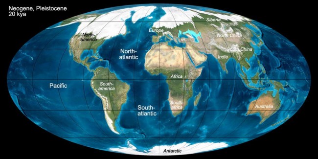
About 18,000 years ago, the Earth began to warm substantially. That was a really big deal, because the Northern Hemisphere was in an ice age. As much as 2 mile (~ 3-4 Km) thick ice sheets blanketed the northern continent. Because so much of the global water supply was locked up in ice, sea level dropped 350 feet (~ 120 m) and beaches and coastlines would have been miles further offshore than their current locations. Coastlines on the Atlantic Seaboard, and presumably globally, contain buried river channels cut deep into the continental shelf. During the Ice Age they weren’t buried, they were river valleys to then more distant shorelines.
A wide lobe of the Cordilleran Ice Sheet crept across the valley of the Clark Fork River, eventually shutting off the flow completely, while the river pooled into the vast watershed behind it, including Missoula Valley, Flathead Valley, Thompson Valley, Mission Valley and Clearwater Valley. By 15,000-17,000 years ago the lake that was created, Glacial Lake Missoula, exceeded 2,000 feet (~ 600 m) in depth, had a surface area of ~3,000 square miles (6,500 Sq Km), and held 600 cubic miles (2,500 cubic Km) of water, as much as Lake Erie and Lake Ontario combined.
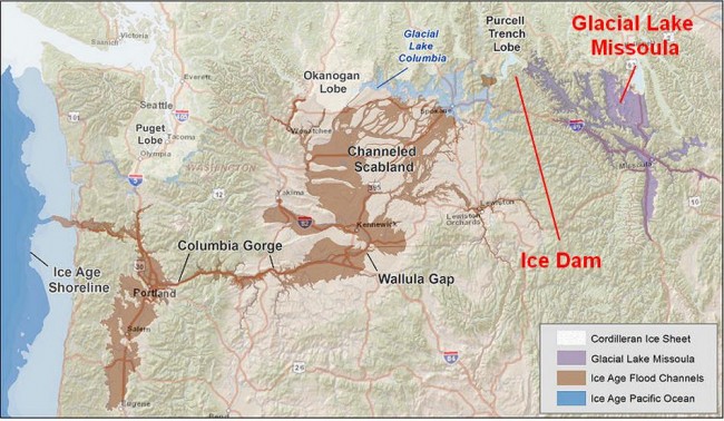
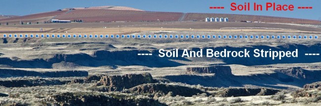
At some point the dam failed. The mechanism is speculative, by probably resulted from high pressure water undercutting the ice, exploiting cracks, fractures and joints in nearby rock in a process called piping, and pressure supported uplift of the of the ice sheet. However it happened, when it failed one of largest freshwater floods in the history of the world cascaded out of Montana and across parts of Idaho and eastern Washington, finally emptying into the Columbia River and eventually the Pacific Ocean. In the process, those regions were almost completely denuded of soil, then had had the bedrock stripped hundreds of feet deep, leaving behind a vast, interconnected series of flat bottomed canyons known as ‘coulees’ and a barren, despoiled, almost lifeless region known as The Channeled Scablands.
Liquids have some interesting properties. One of them is that as they become more saturated with entrained solids and so become denser, they are able to support heavier objects in their flow. Boulders have been known to surf along sitting on top of lahars, volcanic mudflows initiated by erupting volcanoes. So as the flood becomes more turbid, it can lift heavier rocks. The pressure it exerts on objects increases as the square of its velocity, so water moving 4 times faster exerts 16 times more force. So a dense flow that is moving very fast can move enormous pieces of rock and debris.
Another property is that water velocity is a function of pressure and area through which it can move. If a large flow moves through a constriction, the velocity will increase. Likewise, when a constriction opens up to a larger area, the water can get the same flow (same total quantity, or Q) by moving more slowly but over a larger area. And since the velocity drops at these spots, the force the water can apply drops by the inverse square. If the velocity drops to 1/4 of what it was, then it drops all rocks heavier than 1/16 of what it was carrying before. That’s how bars form in rivers. They occur at an area where the water velocity suddenly drops, usually because it’s just downstream of a constriction (or a change in gradient). The water can spread out and so slows down. The heavy rocks get dropped right there. It can’t move them any longer. Another place bars form is in side areas along the flow, coves for example, where water can flow to but can’t flow through, at least flow through quickly. This happens especially during rare, very high condition flood events when banks are overtopped and turbid, debris charged water is flowing over areas that never see flow. As the fast flowing water moves into these areas and finds spots where it can pool or it gets blocked, it slows down quickly, dropping all the entrained rocks and debris. These are called flood bars. The size of the flood bars left behind by the Missoula Flood(s) are gargantuan. Stream gulches along the path completely filled with rock. Areas adjacent to and just downstream of constrictions are mountain sized piles of rock originally stripped upstream.
A third property are the vortexes that can form in water where two streams of water moving at different speeds merge together. Along the wall of two flows, shear forces occur, spinning off tornados in the water. At the base of the tornado, pressure differences produce billions of low pressure bubbles that collapse almost immediately after they form in a process called cavitation. Each collapse produces a tiny shock wave, but billions of them per seconds generates a tremendous amount of energy focused at the base of the vortex. Acting like a hammer drill, it shatters the surface of the rock. Potholes or kettles get drilled straight into the rock under the vortex. The potholes produced in the Missoula Floods are 50 feet (~16 m) deep. That’s a five story building. Into rock.
A final property that’s interesting is that when a fluid flows over a surface with a different density, waves are produced along the boundary layer. We see this when wind flows over the surface of the ocean. We also see it when either wind or water flow over fine sand or silt. The wave pattern gets imprinted into the surface as current ripples.
Here’s Nick Zentner of Central Washington University giving an overview of the local geology of the Scablands and the features of the Missoula floods:
I’ve only scratched the surface of this whole fascinating story. Here’s some further information:
Bretz’s Flood
Huge Floods
The Ice Age Floods Institute (IAFI)
Floods of Lava & Water
Also, look in the Lake Bonneville flood, which may the record holder for the largest freshwater flood ever.
When I worked in Richland WA, I made a trip up to see Dry Falls and Grand Coulee Dam.
Very impressive! Dry Falls is the site of the largest waterfall known on the planet, albeit dry now.
Oddly, Grand Coulee Dam is NOT in the Grand Coulee. It is close to where the head of Grand Coulee approaches the existing Columbia River gorge. The dam uses some of the electricity generated in the dam by the Columbia River to run pumps that lift water from the river up and over the gorge to flow down the coulee and irrigate many many acres of new farm land.
It’s interesting to see some seeds of doubt on current political orthodoxy in the Ice Age Flood site:
Although global warming may now be a serious concern, it is likely that long-term climate cycles will cause large ice sheets to return at some time in the distant future, and cataclysmic outburst floods will probably recur in this region.
Physics is a fascinating area. If I were to have a second life, I would want to spend it with just Physics. The vortex that flipped the F 104 into the XB 70 arose from a similar phenomenon as the potholes in the flood zone.
Amazing story.
“This happens especially during rare, very high condition flood events when banks are overtopped and turbid, debris charged water is flowing over areas that never see flow.”
Not all that rare, actually. See the upbuilt levee banks of the Mississippi River, for instance. The original levees were natural, and added to later by man, in the mistaken notion that you can contain the river at flood stage.
So then, 18,000 years ago the earth began to warm.
I assume the warming was caused by SUVs, diesel engines, coal fired electric generating facilities, the burning of oil and gas, cow flatulence and the evil actions of humans.
After all, the science is settled, is it not??
Global warming, we all know, is caused by HUMAN generation of gaseous carbon which turns into CO2.
Think about this; 18,000 years ago the earth begins a transition to warming from an ice age. So from where did all that CO2 come from that caused the warming??
Answer: HUMAN ACTIVITY !!!
So from where did all that CO2 come from that caused the warming??
Not CO2. Changes in the shape of Earth’s orbit and tilt. They’re called Milankovitch Cycles. There’s also evidence the Sun has periodic changes in the amount of sunlight it produces (the solar flux). CO2 may or may not be influencing global warming. It depends on what data you look at.
I spent two weeks last summer roaming the Channeled Scablands. It was a great vacation. We worked our way down from Sand Point, Idaho, where the ice dams broke all the way down to Portland, Oregon, with side trips everywhere to cover as much as possible.
Tom, sounds like a lot of fun. I’ve never been there but I’d like to see it. A friend of mine took a cruise with his wife up the Columbia River gorge and really enjoyed it. He said the scenery was spectacular.
If you ever get to Cincinnati for a few days it is a great place to tour some of the Ice Age frontier. It was the farthest southern extent of the last continental glaciers. The Natural History museum has a fabulous exhibit where you walk through an ice tunnel at the end lobe of the last big Glacier on to the borders of the land. Wolves, Mammoths and men were there. There are many Paleolithic mounds and some of the earliest discoveries of Mammoths and giant elk in the area. It is a good reminder of how the world could completely change in a relatively short time (and not for the better). Understanding the causes of ice ages is of vital importance, but the work has been hijacked by the warmist faction. Fortunately a lot of the fundamental work continues just with the politically correct paragraphs added to paper abstracts and summaries!
“Understanding the causes of ice ages is of vital importance, but the work has been hijacked by the warmist faction. ”
Yes and it needs to change. A lot of this is just grant manipulation as we saw with the UEA people.
A glacier once ‘neath its collar got hot
And out o’re the scablands a might flood shot.
Now truly, Gilluly, t’ will fool ye,
For Bretz has been there and he says there is not
A shadow of doubt what occurred on that spot.
‘Tis true, it has Jim Gilluly’s goat got.
But speaks he not truly, Gilluly?
– Ode by the USGS Pick-and-Hammer club circa 1952 to James Gilluly, one of J Harlen Bretz’s most insistent critics
It’s now thought that the ice dam failed then reformed as many as 40+ times; so it’s a series of floods, not a single event.
Dry Falls is easier to get to, but Palouse Falls is actually more impressive (if you know what you’re looking at).
The scablands are visible in Google Earth (or Google maps in earth view). Notice the course of the Palouse river just east of Washtucna, WA. Pre-flood, it ran west-then-southwest along SR261 towards Kahlotus, WA. The flood captured it and made a left angle turn south through a new channel to the Snake River.
Highly recommend the book Bretz’s Flood for those with further interest.
I recommend these two guidebooks for touring the Washington Scablands while following the path of the Missoula Floods downstream from Sand Point, Idaho, to Portland, Oregon:
_On the Trail of the Ice Age Floods – Northern Reaches_, Bruce Bjornstad
http://www.amazon.com/On-Trail-Ice-Age-Floods/dp/1879628392/ref=pd_bxgy_14_2?ie=UTF8&refRID=0RB8MHDJC9KVXTYD6EVC
_On the Trail of the Ice Age Floods: A Geological Field Guide to the Mid-Columbia Basin_ by Bruce Bjornstad
http://www.amazon.com/Trail-Ice-Age-Floods-Mid-Columbia/dp/1879628279/ref=pd_sim_14_1?ie=UTF8&dpID=51WAZZ2Q3EL&dpSrc=sims&preST=_AC_UL160_SR107%2C160_&refRID=0PYVY5M5TQJEY9KM32KY
“They’re called Milankovitch Cycles.” I understand that in hand-waving terms they explain the Ice Ages, but not in any detail. The devil is in the detail.
Soviet Of Washington, I read Bretz’s Flood 5 or 6 years ago and I have it linked above. Very enjoyable and well written little book. Part biography (Bretz was a University of Chicago grad, BTW), part detective story, part journey into the world of science and academia in the 1920’s-1950’s. I really enjoyed it.
Ode by the USGS Pick-and-Hammer club…
BTW, this is a pick and hammer. It is to a geologist what a stethoscope is to a doctor. Basic and necessary.
” this is a pick and hammer. It is to a geologist what a stethoscope is to a doctor.”
I noticed the guy in the video had one in his hand much of the time.
Dearieme;
The Earth’s axis completes one full cycle of precession approximately every 26,000 years. At the same time, the elliptical orbit rotates more slowly. The combined effect of the two precessions leads to a 21,000-year period between the astronomical seasons and the orbit. In addition, the angle between Earth’s rotational axis and the normal to the plane of its orbit (obliquity) oscillates between 22.1 and 24.5 degrees on a 41,000-year cycle. It is currently 23.44 degrees and decreasing.
Dearieme, they don’t explain the Ice Ages. They explain the cyclical changes in insolation, the total sunlight reaching the Earth, in 110,000 year, and to a lesser degree 40,000 year, cycles. What they explain extremely well are the interglacial warming periods that are recorded in layers of glacial till, seafloor cores, seashell isotopes, ice cores, and other proxies for paleoclimate.
The Ice Age itself has a different cause. Prior to 4 million years ago, north and south America were not joined. There was an equatorial current that flowed from the Atlantic Ocean to the Pacific between the two. About 4-3 MYA, the Cocos Plate began subducting under the Caribbean Plate which raised a volcanic island arc across that divide, eventually sealing it off completely and forming the Isthmus of Panama. The equatorial current could no longer flow to the Pacific and got diverted around the Gulf of Mexico, around Florida, up the Atlantic Seaboard and past the British Isles where it becomes cool enough to sink into the Arctic Ocean.
That current of warm water, the Gulf Stream, puts warm humid air into the atmosphere at high latitudes. As it rises and cools, the moisture condenses and falls on the high North American and European landmasses as snow in the winter. During the cool periods of a Milankovitch Cycle, there is insufficient sun warmth to melt off all the snow that has accumulated during the winter, and glaciers begin to form. When that happens the albedo of those areas becomes brighter and more of what sunlight that does fall gets reflected back into space, reducing warming even further. In other words, the cooling period of the Milankovitch Cycle and the brightening albedo reinforce each other and the snow and ice accumulation begins to grow exponentially.
During the warming cycles, the ice sheets melt back. That’s called an interglacial warming period. “Interglacial” because there’s no reason to believe the current ice age is over since none of the driving mechanisms have changed. All of human civilization was born and has existed with this latest interglacial warming period.
About 10 years ago a couple of friends and I did a great drive though eastern WA – crossed the border at Republic (didn’t know they had a gold rush) into Alberta and BC. But we stopped at the site of Dry Falls – a state park? It was fascinating…I recommend that drive.
BTW as I was reading this I was thinking if the current Global Warming Crowd ad been around 18,000 years ago (clad in skins no doubt – or would that be objectionable?) they probably would have blamed mastodon dung for the cause of this horrific warming.
“the current Global Warming Crowd”
They will be the next entry some day in MacKay’s book “Extraordinary Popular Delusions and the Madness of Crowds.”
That is if books are still being written and read. If civilization is destroyed by those fools, it may take 2000 years to get back to where we are now. Most Greek writing was lost the past 2000 years.
I live on one of those gravel bars laid down by the Missoula floods. it is a ridge a good 200 to 300 feet higher than the Columbia river in Portland Oregon.
The last time I was through Missoula I saw a billboard that said, “Restore Lake Missoula”.
LOL. Dope is legal there now.