[Jonathan adds: A larger version of this image is below the “Read the rest” link.]
The opening phase of this discussion of Greek soldier, historian Xenophon’s account of the expedition to unseat Artaxerxes King of Persia by his brother Cyrus, has touched on several important elements. First, most important to any great undertaking was logistics, aptly covered in the first post by Fringe. Next, Steven Pressfield introduced the route and how it influenced Alexander the Great, who used the Anabasis of Cyrus as a guidebook in his conquest of Persia decades later. Lexington Green then offered up an overview of the each chapter, laying out the story line in concise detail. Most recently, Joseph Fouche took pen to point out important distinctions between Xenophon’s writing style and that of Herodotus.
The book that most of us have chosen to base our discussion is the translation by Wayne Ambler. In the introduction, Eric Buzzetti writes, “The Anabasis has the makings of a great Hollywood movie.” This statement along should stimulate the most benign reader to pursue the book further. Inside, they will not be disappointed; the story unfolds like a travel log detailing distance traveled, people encountered, battles fought and the unfolding loose republican democracy that formed after the death of their generals at the hand of Artaxerxes. Then becomes what could be described as the one of the great epics combining battles with political intrigue and lessons in leadership.
Anyone who sets out to read this book would do well to prepare themselves by carefully reading the introduction. Then turn to the back and make one’s self familiar with the Historical notes and the Glossary where they will find not only a definition of terms, but an explanation of the scale of measurements which is elementary to follow the journey up country and the escape to safety.
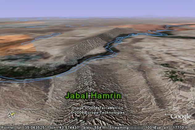
The opening pages of book I, contain two maps tracing the journey into Persia, the retreat north to the Black Sea and back across the Hellespont to Greece. The maps are simple, but can be enhanced, courtesy of Google Earth and 21st century technology, for a true look at the lay of the land. Here are some of the highlights to be discovered when perusing the route in this manner.
As one looks at the first part of the journey up country across today’s Turkey, they will note that the land contains sustainable resources that Cyrus’s expedition could harvest by trade or pillage. Each stage, five parasangs, (3.3 miles) of the journey is logged in the text, giving amateur geographers a chance to demonstrate their skills. Rivers are noted for their width and potential bounty of fish, and towns, for their accommodation or resistance.
Tracing the journey with the help of Google Earth allows for a birds eye view of the challenges that await the Ten Thousand. For example, the five stages, (115 miles) that led from Araxes River across the Syrian Desert to the Mascas River were described as barren and devoid of life. The view today reveals that little has changed in 2500 years. The Euphrates River, a dam now blocking its upper reaches, still stretches like a green ribbon across the breadth of western Babylon. The route soon to be followed by the Ten Thousand up the Tigris traces a green line of irrigated farmland. This land along the Tigris was the lifeline that the Ten Thousand followed as they fought north to the relative safety of the mountains, home of the Carduchoi, ancestors of today’s Kurdish people.
Looking down on this route, one sees the logic of why Xenophon convinced the army to take this route. Going back across the desert would expose them to two dangers. The land just traversed was still feeling the footprints of all who traveled with Cyrus, 110,000 strong, (including the 10,000 Greek hoplites). Second, it was a flat table land that gave the advantage to the Persian cavalry. The mountains however unknown, offered the Greeks a chance to alter their tactics by changing the formation to a hollow square to guard their baggage train. They added more sling throwers, (peltastai) who used lead pellets, for longer distance to stave off the approach of the Persians. As they entered the mountains most of the Persian army stopped pursuing in the belief that the winter would destroy the Greek army.
Looking down on those mountains today from the lens of Google Earth, one can zoom into observe the valleys and gain an appreciation of the challenge of finding a route across the mountains to the sea and the Greek Colonies along its shore. Scouting parties were formed to range ahead to find routes and warn of potential enemies. The army was beginning to resemble what we today would call a combined arms force, with heavy infantry, cavalry, scouts, artillery (sling throwers) and support (camp followers) all arrayed together to accomplish their goal.
The Greek colonies found along the Black Sea offered no sure guarantee of safety, since feeding and supporting ten thousand uninvited soldiers strained even the most affluent colonies larders. The unfolding story of this part of the journey waits to be discussed.
Stepping back to the first book, understanding the tone of the author requires the reader to know that it is being written in the voice of Theopompus, the pseudonym for Xenophon. His viewpoint, although detailed in matters of logistics, geography and military matters is that of a Greek who views all others as Barbarians whose social habits fall below the station of any Greek. The author’s note that Theopompus means “God-sent” is a sign that Xenophon holds his own self-worth in the highest degree, even when writing in the third person.
As we prepare to leave book I, the Greek Hoplites and their generals, basking in the tactical victory of the Battle of Cunaxa are unaware of the fate that awaits them. Book II will open the reader’s eyes to new dangers, tales of audacity and examples of oratory that still echo down through the ages.
Excellent post.
Makes you wish you had a geocoded e-Anabasis with embedded longitude/latitude coordinates so you could get a fix on the approximate location of the Ten Thousand as you read it through. It’ll probably be 10 years before it happens but the technology exists now.
I tried to just exactly this as I was both reading the book, and generating posts. While I could easily get an idea of what the terrain is like, I had a very difficult time tracing the exact route. I suspect that erosion and civil engineering have altered the terrain, particularly in the southern reaches of this epic. I was hoping to trace the first part of the retreat through Carduchia and Armenia, but was unable to do so. Have you been able to identify any of the terrain from this part of the retreat? Very nice post.
Joseph,
I agree an overlay of the route would be something that could be done on Google maps along with a geocoded guidebook if someone was motivated. Perhaps someone soon will write a good screenplay and this becomes that “Great Hollywood movie”, which will advance mega interest.
Fringe,
I found these two sources for maps. Perhaps they will help. Problem with using Google maps is the identifying the rivers and place names amid the clutter that occurs when you add layers.
Here are the two links
http://www.arkeologi.uu.se/ark/education/CD/Cuppsats/Rashid.pdf
http://rbedrosian.com/Maps/cah61.htm