Air space control was one of the themes of my previous, April 4, 2014, column “Unit Conversion Error in the Pacific War” when it looked at the issues of coordination between military services over how to use Radar in terms of units of distance and grid type versus polar type reporting of Radar position data in order to control air space around air fields and naval task forces.
Expanding on that theme, today’s column is one about a forgotten lesson of World War 2 (WW2) global warfare from the South West Pacific Area in 1943 that was repeated by the North Atlantic Treaty Organization (NATO) in the “Operation Allied Force” Air War over Kosovo in 1999. How it happened requires returning to a theme from my previous Pacific War history columns, namely, that you don’t know a thing about how a military theater in WW2 fought without knowing how they used their Radars. That’s because changing electronic technology in the form of Radar revolutionized things like airspace control, gunnery and weather forecasting simultaneously in the middle of a World War, and its deployment and use were very uneven between military services and allies based on that theater’s overall priority. Something very similar happened in 1999 with the uneven deployment of digital technologies between American military flying services and those of its European NATO allies.
In WW2, issues arising from those Radar based changes often wound up affecting decisions at the strategic and political policy levels of military theaters, hidden unnoticed for decades under layers of classification and post-war institutional reputation polishing. The role of air space control in the South West Pacific Theater’s June 1943 Operation Chronicle was a perfect example of this. Specifically how units of the same military service — US Army Air Force in the form of General MacArthur’s 5th Air Force and Admiral Halsey’s 13th Air Force — in two adjacent military theaters differed so greatly in how they controlled their air space they couldn’t talk to one another. These “hidden from history by post-war institutional agenda” differences in 1943 Global Coalition War reemerged in NATO’s 1999 Kosovo War Air Campaign with a vengeance.
SETTING THE STAGE
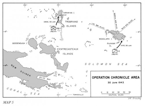
The figure below is from the foremost institutional history on Operation Chronicle, John Miller’s “Cartwheel: The Reduction of Rabaul” from the US Army in WWII “Green Book” Histories.