Jim Bennett’s New Book

A Time For Audacity: New Options Beyond Europe

—-

As we approach tomorrow’s long-awaited referendum on continued UK membership in the European Union, James C. Bennett, author of The Anglosphere Challenge, co-author of America 3.0 and friend of this blog has a new short book out that deserves attention.

From the book’s Amazon page:

For Britons, Canadians, Australians, and New Zealanders, and their friends and allies, the time has come to consider an audacious option. It is time for many reasons. One is that each of you today faces a series of critical decisions about what and who you are and will be. Britain less than two years ago passed one such decision point, which is whether the historical British Union of the four nations would continue together. Although the option of full independence for Scotland was rejected, the question of how the four nations will work together, and in what sort of framework, has now been opened, and it is time for the options that this book will discuss to be part of that discussion.
 
Now, Britain is on the verge of making another decision threshold about another Union. Again, this is an issue where the answer appears obvious to an outsider, but seems to be a matter of great controversy within the UK. There may be valid reasons why Britain might not want to exit the European Union, but the lack of adequate alternatives for closer trade relations and partnership should not be one of them. Ironically, many of the arguments of advocates of British membership in the EU work better as an argument for the option presented in this work, a Union of the Commonwealth Realms.

You can read the rest and order the book (Kindle download only) here.
Rough-Hewn Land: California to the Rocky Mountains

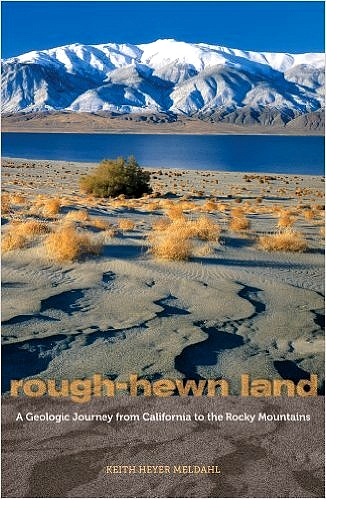
RoughHewnLandKeith Meldahl, a geologist and professor of geology, has written one of the most interesting books on the history of the American West I’ve ever encountered. It’s a history of how it got the way it is, physically. He covers the creation of California – it’s only recently been pasted onto North America – how the Sierra Nevada formed and what it actually is, why Nevada looks like it does, how the Colorado Plateau got there, how the Rocky Mountains were formed, and some very interesting and odd details as well. Along the way, he provides a few vignettes of the early explorers and settlers and their often brutal encounters with these features.
Probably the two most important players in all this are something you’ve never heard of, the Farallon Plate, and the North America continent itself. Long story short, 240 million years ago   the world’s landmasses had merged together into single massive conglomeration called Pangea (All Land). Prior to that time, North America had moved West to East, the East coast was the active margin and the West coast, which then ended in a line from Wyoming across Utah and through Nevada, trailed along. The eventual impact with Africa raised the Appalachians to Himalaya scale and merged us to it like India to Asia. By 150 million years ago, Pangea was breaking apart and a newly born mid-ocean ridge opened the Atlantic Ocean for the first time. As the ridge continued to build new seafloor, it spread apart. Everything east  of that ridge began being pushed to the east, and everything west  of it, including North America, began being pushed to the west. It was then that things began changing for the western states. You can page through that 100 million years at Arcadia Street for a glimpse at the plant and animal life you would have seen, had you been there.

Read more

The Ice Age Floods

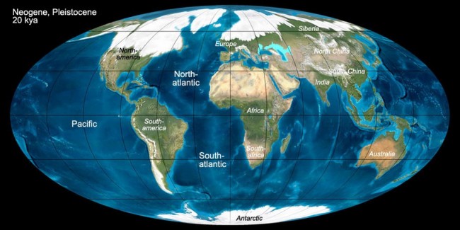
About 18,000 years ago, the Earth began to warm substantially. That was a really big deal, because the Northern Hemisphere was in an ice age. As much as 2 mile (~ 3-4 Km) thick ice sheets blanketed the northern continent. Because so much of the global water supply was locked up in ice, sea level dropped 350 feet (~ 120 m) and beaches and coastlines would have been miles further offshore than their current locations. Coastlines on the Atlantic Seaboard, and presumably globally, contain buried river channels cut deep into the continental shelf. During the Ice Age they weren’t buried, they were river valleys to then more distant shorelines.

Last Glacial Maximum, 20.000 years ago
Last Glacial Maximum, 20,000 years ago

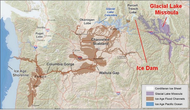
A wide lobe of the Cordilleran Ice Sheet crept across the valley of the Clark Fork River, eventually shutting off the flow completely, while the river pooled into the vast watershed behind it, including Missoula Valley, Flathead Valley, Thompson Valley, Mission Valley and Clearwater Valley. By 15,000-17,000 years ago the lake that was created, Glacial Lake Missoula, exceeded 2,000 feet (~ 600 m) in depth, had a surface area of ~3,000 square miles (6,500 Sq Km), and held 600 cubic miles (2,500 cubic Km) of water, as much as Lake Erie and Lake Ontario combined.

Glacial flood map, 17,000 - 15,000 years ago
Glacial flood map, 17,000 – 15,000 years ago

Read more

Private Enterprise, Public Space

Some time since (Oh, heck was it in 2005, ten years ago? So it was.) I mused on the concept of public space, both in the general sense of a large city and the smaller sense, of a neighborhood … that is, the place that we live in, have our gardens and our households, where we have neighbors who know us, where we jog, walk our dogs, take an interest from the mild to the pain-in-the-neck over-interested and judgmental. If our homes are our castles, then the neighborhood is our demesne.
And unless we are complete hermits, home-owners will take an interest in the demesne. I state that without fear of contradiction, and it does not matter if that demesne is in a strictly-gated upper-middle or upper-class community with real-live 24-hour security, a private and luxurious clubhouse with attached pool and attractively-landscaped park or a simple ungated, strictly crisscrossed-streets and cul-de-sacs development of modestly-priced starter houses without any HOA-managed extras like golf courses, swimming pools, fitness centers, jogging paths indeed, anything beyond a little landscaping around the sign denoting the entrance to the development. This is where our homes are, and at the lower end of the economic scale of things, likely to have consumed a major portion of disposable income on the part of the householder. A good portion of our material treasure, in other words, is committed to those foundation, walls, roof and yard.

Read more

History Weekend: Stephens, Townsend, Greenwood, Murphy

(An early version of this essay began as a sorrowful rant about the lack of good adventure movies a number of summers ago. It turned into a multi-part blog post, and then into a novel about the first wagon-train party to get their wagons over the Sierra Nevada in winter yet. They got lost, had to break up into separate groups, were caught by winter while still in the mountains, nearly ran out of food … but unlike the Donner Party of two years later, this party managed to hang together and negotiate the mountain obstacle without any loss of life. This is part one of two.)

In comparison to the notorious and hard-luck Donner-Reed Party, hardly anyone has ever heard of a similar wagon-train company who crossed over almost the exact same trail two years previously. The party led by Elisha Stephens and John Townsend, and advised by the old mountain-man, Caleb Greenwood, walked much of the way between the Mississippi-Missouri and the Sacramento Rivers, across plain and desert, blazed a trail up the wilderness of a steep canyon, and finally hauled wagons up a sheer mountain cliff. Generally they remain a footnote in the history books, mostly noted for being the first to bring some of their wagons up the Truckee River canyon and over the Sierra Nevada into California. There was no tireless letter-writer or professional memoirist among them, no extensive first-hand accounts, although John Townsend, a medical doctor and Mason may have kept a diary.

In the year 1844, only a bare handful of explorers, missionaries and fur trappers had ever seen for sure what lay beyond the jumping-off points at Council Bluffs, Independence, St. Joseph. There was southern trail to Santa Fe, and beyond that to the thinly-populated enclave of Spanish and then Mexican territories in California, and a northern track which followed along the Platte River and terminated in Oregon Territory. Lewis and Clarke, and William Ashley’s fur-trapping brigades all had gone that way, by boat, horseback or on foot. Hearing of the rich lands in the Pacific Northwest, farmers and small tradesmen also began following the siren call. This was not a journey for the impoverished. Besides a wagon, and stock to pull it, the journey required a six-month food supply, tools, clothes, bedding and cooking gear. There might be space in the wagon for books, and other small treasures, for the wagons were small, and food took up most of the space. The draft animal of choice was not the horse, as many would think. Horses were expensive, and the road was too rough in the early days for even the toughest horse in dray harness. Mules made a good showing on the southern trail, but they were also expensive. Most emigrants could better afford ox teams; four to six pair to a wagon, guided by a driver who walked by the lead team and controlled them by verbal commands.

Read more