Ancient DNA, Genetics and Race

UPDATE: Greg Cochrane is doing chapter by chapter discussion of the Reich book so I will just link to his discussion. This week it is the chapter on India.

On the whole, people from North India have more ANI ancestry, while people in southern Indian have more ASI ancestry. The proportions generally range from 80% ANI to 80% ASI. There are actually a few populations that are close to unmixed ANI (Kalash) or unmixed ASI (tribal populations in South India such as Palliyar, Ulladan, Malayan, and Adiyan). Groups that speak Indo-European languages typically have more ANI, while those speaking Dravidian have more ASI. Populations (including castes) with higher social status generally have more ANI ancestry. The Y-chromosome and mtDNA patterns show that ANI contributed a disproportionate fraction of male ancestry, while ASI accounts for the great majority of female ancestry again, much like Latin America.

The Y chromosome suggests male ancestry in a situation where the male conquerer mates with female conquered tribes.

The Brahmins have the highest proportion of ANI or Indo European genetic material.

I don’t know how many here are interested in this but the new book by David Reich may prove to be as revolutionary as Murray’s “The Bell Curve”.

I’m reading the new book, “Who We Are and How We Got Here”.
Read more

Civil war or just uncivil society?

It seems that at least once a week I read an article predicting that the extreme political divisions in our country will lead to an actual civil war. “The country hasn’t been this divided since 1860!” is a common refrain.

Divided, yes. But leading to war? I don’t think so.

Those who actually know all about our Civil War may wish to correct me; I admit that discussion of this topic in my Georgia high school was so frequent and so prolonged that I did my best to sink into a coma whenever the subject came up. Even so, I think I grasped a few general points about that war which differentiate it from the present situation.

(1) The war was driven by one major moral/economic dispute, even if the two sides described it differently. (North: “Slavery is wrong.” South: “Our economy depends on slavery. Besides, states’ rights.”)
(2) The opposing sides were (mostly) geographically divided.
(3) There were, on both sides, people who were willing to actually fight with something more lethal than a sarcastic Tweet.

Now look at the current mess.

Read more

Why does George Soros try to destabilize the West ?

George Soros is a Hungarian born billionaire who seems to be funding a lot of malicious mischief around the world. Why ?

Soros was born in Hungary in 1930.

That Wiki article is very favorable to Soros and does not mention a few things.

There is considerable discussion of Soros’ role under the Nazis.

It has been alleged that he was a collaborator. Apparently, he did admit doing some things that could be criticized although the role of a 14 year old is pretty weak.

It was a tremendous threat of evil. I mean, it was a — a very personal experience of evil.

KROFT: My understanding is that you went out with this [Christian] protector of yours who swore that you were his adopted godson.

Mr. SOROS: Yes. Yes.

KROFT: Went out, in fact, and helped in the confiscation of property from the Jews.

Mr. SOROS: Yes. That’s right. Yes.

KROFT: I mean, that’s — that sounds like an experience that would send lots of people to the psychiatric couch for many, many years. Was it difficult?

Mr. SOROS: Not — not at all. Not at all. Maybe as a child you don’t — you don’t see the connection. But it was — it created no — no problem at all.

KROFT: No feeling of guilt?

Mr. SOROS: No.

Read more

History Friday — Imperial Japan’s Philippine Radar Network 1944-45

It is amazing the things you find out while writing a book review. In this case, a review of Phillips Payson O’Brien’s How the War Was Won: Air-Sea Power and Allied Victory in World War II. The book is thoroughly revisionist in that it posits that there were no real decisive land battles in WW2. The human and material attrition in those “decisive battles” was so small relative to major combatants’ production rates that losses from them were easily replaced until Anglo-American air-sea superiority — starting in the latter half of 1944 — strangled Germany and Japan. Coming from the conservative side of the historical ledger, I had a lot of objections to O’Brien’s book starting with some really horrid mistakes on WW2 airpower in the Pacific.

You can see a pretty good review of the book at this link — How the War Was Won: Air-Sea Power and Allied Victory in World War II, by Phillips Payson O’Brien

However, my independent research on General MacArthur’s Section 22 radar hunters in the Philippines proved one of the corollaries of O’Brien’s thesis — Namely that the Imperial Japanese were a fell WW2 high tech foe, punching in a weight class above the Soviet Union — was fully validated with a digitized microfilm from the Air Force Historical Research Agency (AFHRA) at Maxwell AFB, Alabama detailing the size, scope and effectiveness of the radar network Imperial Japan deployed in the Philippines.

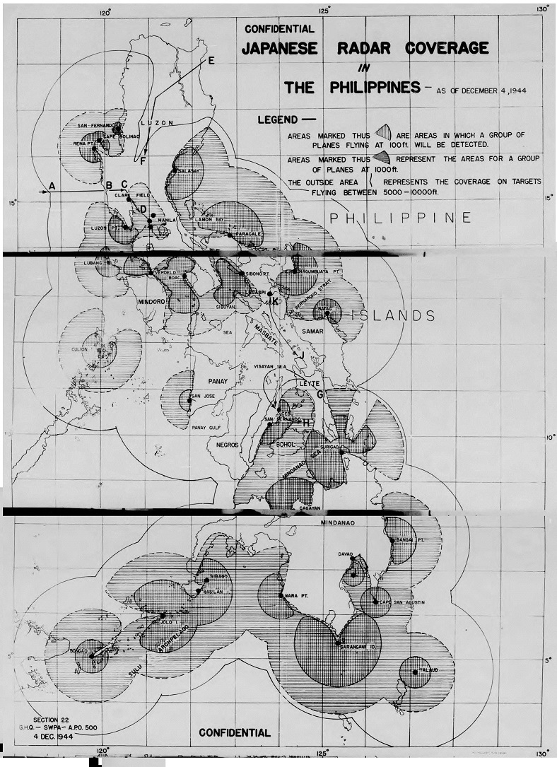
The microfilm reel A7237 photoshop below is a combination of three scanned microfilm images of an early December 1944 radar coverage map of the Philippines. It shows 32 separate Imperial Japanese Military radar sites that usually had a pair of Japanese radars each (at lease 64 radars total), based upon the Japanese deployment patterns found and documented in Section 22 “Current statements” from January thru March 1945 elsewhere in the same reel.

This is a early December 1944 Japanese radar coverage map made by Section 22, GHQ, South West Pacific Area. It was part of the Section 22 monthly report series.

This Section 22 created map — taken from dozens of 5th Air Force and US Navy aerial electronic reconnaissance missions — showed Japanese radar coverage at various altitudes and was used by Admiral Halsey’s carrier fleet (See route E – F on the North Eastern Luzon area of the map) to strike both Clark Field and Manila Harbor, as well as by all American & Australian military services to avoid Japanese radar coverage to strike the final Japanese military reinforcement convoys, “Operation TA”, of the Leyte campaign.

Read more

D-Day, June 6th 1944, Plus 72 Years

To commemorate D-Day, here is a current view of Omaha Beach from Wikipedia —

https://en.wikipedia.org/wiki/Omaha_Beach#/media/File:Omaha_Beach_Nowadays.jpg

And here are a pair of columns I’ve written previously on D-Day in 2014 and 2013.

This is a review of three very good books on D-Day —

History Friday — Books to Read for the D-Day 70th Anniversary
6th June 2014

And this column is about the sacrifices of British Royal Air Force early warning radar unit, the 1st Echelon of 21 Base Defence Sector, that landed at the Les Moulins Draw, on Omaha Beach, Normandy about 5:30pm on 6 June 1944.

Royal Air Force at Omaha Beach
6th June 2013